
What Gardeners Can Learn from Washington Ecoregions
In this episode of The Evergreen Thumb, host Erin Hoover defines an ecoregion and introduces listeners to 8 Washington ecoregions.

Affiliate Disclosure: As an Amazon Associate, the Master Gardener Foundation of Washington State earns from qualifying purchases. When you buy through our links, you’re helping The Evergreen Thumb Podcast grow—just like good fertilizer! Product recommendations are our own and do not represent the views of MGFWS or Washington State University. Thanks for supporting us!
Host Erin Hoover explores Washington State’s ecoregions, explaining how these regions—based on factors like soils, climate, and vegetation—are important for gardeners to understand. Each region, from the rain-drenched Coast Range to the arid Columbia Plateau, present unique gardening challenges and opportunities. She encourages listeners to learn about their own ecoregion and to choose the best plants for their gardens for gardening success.
The 8 Washington ecoregions that Erin covers are:
- The Coast Range
- Puget Lowland
- The Cascades
- The North Cascades
- Eastern Cascade Slopes
- The Columbia Plateau
- The Blue Mountain Region
- The Northern Rockies
Erin is the WSU Extension Master Gardener Program Coordinator in Grays Harbor and Pacific Counties. Before becoming WSU staff, she was a Master Gardener volunteer for more than 10 years. Growing up surrounded by Washington’s lush landscapes, she’s always felt connected to nature, which eventually led her to become a Master Gardener and Permaculture Designer and to dedicate her work to helping others garden successfully.
As a modern homesteader, Erin has turned her property into a small, thriving farm. She grows veggies, tends to fruit trees and shrubs, and raises livestock, all while keeping sustainability in mind. Her focus these days is on finding new uses for native plants, finding ways to feed her animals from her land, and growing her own food.
When she’s not working on the homestead or recording The Evergreen Thumb, you’ll find Erin out exploring Washington’s mountains, forests, and beaches, bringing new ideas home to try in her own garden.
Listen Now



Resources for Washington Ecoregions
- Level III Ecoregions of the Continental United States | US EPA
- Level III and IV Ecoregions of Washington map (PDF)
- Washington ecoregion text descriptions
- WNPS
- Burke Herbarium Image Collection
- 2023 USDA Plant Hardiness Zone Map | USDA Plant Hardiness Zone Map
- Web Soil Survey – Home for address-level soil data
- Northwest Native Plant Guilds: How to Design Low-Maintenance Gardens
Transcript
Erin Hoover (00:00)
Welcome to episode 84 of The Evergreen Thumb. I’m Erin Hoover, and today I’m going to talk a bit about the level III ecoregions in Washington State.
Washington grows both rainforest and sagebrush steppe. So statewide gardening advice often only fits a small portion of the state. Back in episode 62, I kind of talked about this a little bit, but I was more focused on native plant guilds that would thrive in these ecoregions.
What is an Ecoregion?
So today I’m going to go in depth a little bit more on the different ecoregions and what that looks like for home gardeners. These ecoregions were developed by the EPA to kind of help classify the different climates.
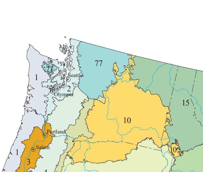
Ecoregions are areas of similarity in ecosystems and in the type, quality, and quantity of environmental resources. The system has four levels. Level I is the broadest and level IV is the finest. So level III is kind of more practical at a gardening scale. And if you’re not in Washington, I will include a national map of level III ecoregions.
Regions are mapped out from geology, vegetation, climate, soil, land use, and hydrology. So there’s a lot of input that went into these ecoregions.
You might think, well, how does this relate to hardiness zones? Hardiness zones only track the winter low temperature, the average low temperature, while ecoregions reflect rainfall, soil types, and the vegetation that grows there. Level IV subregions are much more detailed. So if you live near the boundary of a level III, you might look at the level IV map.
I can include a link to that as well in the show notes.
There are eight ecoregions within Washington. And I’m going to work west to east. The first one is the coast range.
The Coast Range: Rainforests
The low mountains of the coast range of western Washington are covered by highly productive, rain-drenched coniferous forests.
This region is known for its Douglas Fir plantations that are prevalent on the intensively logged and managed landscape. Landslides and debris slides are common.
Coastal headlands, high and low marine terraces, sand dunes, and beaches are also prominent characteristics in this region, and this includes the lower Olympics. This region is driven by marine influence, a long winter rainy season, summer fog that reduces plant moisture stress, and very few temperature extremes.
The low Olympics is a subregion of this, or a level IV region that gets up to about 200 inches of rain per year. The soil is characterized by sand dunes and marine terraces on the coast and erodible silt and clay in the Willapa Hills and generally acidic wet forest soils.
Some of the key native plants in this range are Sitka Spruce, Western Hemlock, Western Red Cedar, Douglas Fir, Shore Pine, Salal, Evergreen Huckleberry, Sword Fern, Salmonberry, Kinnickinnick, and Beach Strawberry. So the key garden implications on the coast range are wind and salt tolerance, drainage in some of the more clay soils, acid-loving crops, cool-season vegetables with lots of slug and fungal pressure.
And some of the subregions, or level IV regions, include the coastal lowlands, the coastal uplands, the low Olympics, and the Willapa Hills.
Puget Lowland: Microclimates
The second ecoregion I’m going to talk about is the Puget Lowland. So this is primarily the area around Puget Sound. This is a broad rolling lowland characterized by a mild marine climate. It occupies the continental glacial trough and is composed of islands, peninsulas, and bays in the Puget Sound area. Coniferous forests originally grew on the ecoregion’s ground moraines, outwash plains, floodplains, and terraces.
The climate drivers include a mild maritime climate with an Olympic rain shadow.
The Olympic rain shadow is a weather phenomenon that prevents rainfall from reaching the Olympics from the west, so the areas to the east of the Olympic Mountains tend to get less rainfall. That Olympic rain shadow subregion only gets ten to forty inches a year.
The San Juan Islands hold the driest vegetation types. So the soils in the Puget Lowlands are glacial deposits. Central Puget Sound has well-drained gravelly soil with limited moisture holding. The San Juans have shallow, well-drained soil, and the Olympic rain shadow has loamy soil that holds moisture better.
The key natives in this region are Douglas Fir, Western Red Cedar, Big Leaf Maple, Vine Maple, Garry Oak, Camas, snowberry, Red Flowering Currant, Nootka Rose, Oregon Grape, and Sword Fern.
So, some of the implications for your garden if you live in this region are that mulch and irrigation planning are going to be key for those dry summers and gravelly soils. Rain gardens are a good option for poorly drained till. This region has one of the widest plant palettes in the state. You can also look at the level IV maps to see the microclimates. There are a lot of microclimates in all of these regions, but especially in the Puget Lowland.
Some of the subregions in the Puget Lowland include the Fraser Lowlands, San Juan Islands, the Olympic rain shadow, Central Puget Lowlands, and the Southern Puget Prairies.
The Cascades: Mountain Climate
The next ecoregion is the Cascades. This mountainous ecoregion stretches from the central portion of Western Washington down through Oregon and into Northern California. Much of the region has been affected by alpine glaciation, and the western Cascades are older, lower, and dissected by numerous steep-sided stream valleys.
Some peaks within the Cascades reach over 14,000 feet. That would be Mount Rainier. Soils are mostly of cryic and frigid temperature regimes. The Cascades have a moist, temperate climate that supports an extensive and highly productive coniferous forest that’s intensely managed for logging, and subalpine meadows and rocky alpine zones occur at the highest elevations.
So this is actually more of the southern half of the Cascades, but it is a moist temperature climate with a deep snowpack in the highlands. The subalpine and alpine areas have very cold winters and an extremely short growing season. The soils include a lot of volcanic parent material.
There is cold elevation, and the soil is very thin and rocky near and above the treeline.
This is where we start to see some change in the native plant profile. Of course, Douglas Fir, but also Pacific Silver Fir, Noble Fir, Mountain Hemlock, Subalpine Fir, White Bark Pine, Vine Maple, Huckleberries, Bear Grass, and Avalanche Lily.
So the elevation of the Cascades is going to dictate your plant choices more than latitude. You gotta think snow load, frost-hardy selections, and that gritty, fast-draining rock for the alpine-type plants. That till and that scree are very fast-draining. And so, a lot of those alpine plants are very water-efficient.
Some of the level IV names for this region include the Western Cascade Lowlands and Valleys, the Western Cascades Montane Highlands, Cascade Crest, Montane Forest, and Cascades Alpine / subalpine.
The North Cascades: Rugged Terrain
The North Cascades is the fourth ecoregion I was going to talk about. Obviously, it’s the north half of the Cascades in Washington, but it’s also physically wider than the Cascades.
The terrain of the North Cascades is composed of high, rugged mountains. Climate drivers include maritime rainforest conditions on the west. Sixty to ninety inches in the lowland forests, and a dry continental climate in the east. The region also holds the greatest concentration of active glaciers in the lower forty-eight states.
The soils are made of a lot of sedimentary and metamorphic rock, unlike the volcanic Cascades. The Chelan Tephra Hills have coarse volcanic ejecta, and the Chiwaukum area has erodible sandstones.
For natives, the west side has Western Hemlock, Red Cedar, Doug Fir, Pacific Silver Fir, Mountain Hemlock, Vine Maple, red huckleberry, and Sword Fern. The east side has Ponderosa Pine, Douglas Fir, Subalpine Fir, Bluebunch Wheatgrass, and Idaho Fescue.
There are really two very different gardening styles in one region. Aspect and elevation have a big effect on which plants work. The difference between the two sides of the mountains almost makes it feel like it should be two separate regions.
The coarse east side soils need more organic matter, and there’s risk of erosion on slopes.
Some of the level IV subregions include lowland forests, highland forest, subalpine, alpine, Pasayten / Sawtooth highlands, Okanogan Pine / Fir Hills, Chelan Tephra Hills, and the High Olympics.
Eastern Cascade Slopes: Fire Risk and Drought Tolerance
And then continuing to move east, we have the eastern Cascade slopes and foothills.
The eastern Cascade slopes and foothills are actually a very long, narrow band just east of the Cascade ecoregion.
This is part of the Cascade rain shadow. There are greater temperature extremes, less precipitation, and vegetation is highly susceptible to wildfire. Soils are highly variable, with volcanic cones and buttes and frigid soils in the higher grand fir mixed forest. Natives are Ponderosa Pine, Lodgepole Pine, Garry or Oregon White Oak, Doug Fir, Antelope Bitterbrush, Mock Orange, Serviceberry, Arrowleaf Balsamroot, Bluebunch Wheatgrass, and Idaho Fescue.
This region is really important to think about firewise design and defensible space, the use of drip irrigation and mulch, and plants that are rated for both drought and hard freezes.
This area includes subregions of the Yakima Plateau and slopes, the Grand Fir Mixed Forest, Oak Conifer, eastern Cascades, and Columbia Foothills. It has a more continental climate than ecoregions to the west, and it is distinguished by open forests of pine versus the higher regions to the west where it’s mostly hemlock and fir.
The Columbia Plateau: Arid Steppe
The next ecoregion is the Columbia Plateau. The Columbia Plateau is an arid sagebrush steppe and grassland, surrounded on all sides by moisture-predominantly forested mountainous ecological regions. This covers the majority of central and eastern Washington.
This region is underlain by basalt up to two miles thick. It is covered in some places by loess soils that have been extensively cultivated for wheat, particularly in the eastern portions of the region where precipitation amounts are greater. During glaciation in the Pleistocene era, parts of the area were scoured to bedrock by huge floods from breached ice dams.
Again, it’s arid steppe and in the Cascade rain shadow. The Pleistocene lake basins get 6 to 12 inches a year, whereas the loess islands get 7 to 18 and the Palouse Hills get 16 to 23.
The summers are hot, and the winters are cold. Sometimes this is also called high desert because it does get quite cold, so as not to confuse it say with a southwest type of desert.
Soils in this region are typically wind-deposited loess over basalt and thin, rocky soil in the channeled scablands where the floods scoured the soil. The Palouse loess has higher organic matter and clay. And arid soils are often alkaline, so a soil test is definitely a good idea in this region.
Natives in this area, you’re getting again into the more steppe high desert type plants like Sagebrush, Stiff Sage; there are several types of sage; Bluebunch Wheatgrass, Idaho Fescue, Sandberg’s Bluegrass, Rabbitbrush, Arrowleaf Balsamroot, and even Prickly Pear Cactus.
In this region, irrigation is going to be your biggest variable. You need to be able to protect from the wind, which is going to desiccate plants and require watering more often, but you can do a lot of the heat-loving vegetables as long as you irrigate, and native bunchgrass plantings are a great option.
Some of the level IV names include the Channeled Scablands, Pleistocene Lake Basins, Loess Islands, Yakima Folds, Palouse Hills, and the Okanogan Valley.
The Blue Mountain Region
The Blue Mountain ecoregion only comes up into just the very southeast corner of Washington, right at the northern edge of the Blue Mountains. It’s a complex of mountain ranges that are generally lower and more open than the Cascades.
Like the Cascades, but unlike the Northern Rockies, it’s mostly volcanic in origin. Unlike the bulk of the Cascades, much of this region is grazed by cattle.
As I said, it’s mostly volcanic mountains where snow can persist late into the spring. It’s a maritime influence zone because of the moisture through the Columbia River Gorge, whereas the lee-side canyons are drier. The soil is loess at lower elevations with a moderately high water-holding capacity, and an ash layer at higher elevations helps hold some moisture. Then there are stony canyon slope soils that retain little moisture.
Natives are going to be very similar to the Columbia Basin, including Ponderosa Pine, Douglas Fir, Grand Fir, Engelmann Spruce, Subalpine Fir, Whitebark Pine, Bluebunch Wheatgrass, Sandberg’s Bluegrass, Snowberry, and Wild Rose.
In this region, the moisture changes sharply with elevation and aspect. So late snow, shortened seasons at elevation, and stony sloped soils need organic matter.
As I mentioned, there’s only a small sliver of this region in Washington.
The Northern Rockies: Mountainous Terrain and Vegetation
Okay, and then the northwest corner of Washington is known as the Northern Rockies. The Northern Rockies ecoregion is mountainous and rugged, and despite its inland position, both climate and vegetation are typically, but not always, marine-influenced.
The Northern Rockies ecoregion is not as high nor as extensively snow- and ice-covered as the Canadian Rockies. This ecoregion goes through much of Idaho and into western Montana to give you kind of an idea that it’s a very similar ecoregion. There are thick volcanic ash deposits in portions of this region, and logging and mining are both very common in the Northern Rockies ecoregion.
As I mentioned, the thick volcanic ash can improve water retention.
The Okanogan and Colville valleys are gravelly and stony, and the Spokane Valley has a coarse, gravelly outwash.
The natives include Western Larch, Western White Pine, Western Red Cedar, Western Hemlock, Grand Fir, Ponderosa Pine, Ninebark, Ocean Spray, Snowberry, Antelope, Bitterbrush, Paper Birch, and Quaking Aspen.
And this again is a region where there are a lot of differences within the region. So dry valley gardens versus moist northeast gardens are very different. And so you want firewise plantings in the dry forest, you want cold-hardy selections, and you need organic matter in those gravelly soils. Some of the level IV names are Okanogan Highlands, the Okanogan-Colville xeric valleys and foothills, the Spokane Valley, and inland maritime foothills and valleys.
And that covers all eight ecoregions in Washington.
Matching Plants to Your Washington Ecoregion
So, I have three questions that I would like you to consider. What is my ecoregion? What is my rainfall pattern? And what are my soil and wind conditions?
I will include a level IV map too, so that if you’re kind of on the line, you can look and see about where you live and if you can get a better idea from a level IV ecoregion. If you live near one of those boundaries, you may not match that regional description.
And then I want to encourage you to pair your ecoregion with local expertise, whether that’s from a local nursery or your county master gardener program. They can help you make informed decisions about building a garden that matches your ecoregion.
I will include links to the level III and level IV ecoregions in the continental United States. The EPA has that. The Washington Native Plant Society is a great source to look up some of those native plants, as is the Burke Herbarium Image Collection, and I will put links to both of those in the show notes as well.
So I hope you found that helpful and can get kind of a better understanding of how the geology and the geography can impact your climate, your soils, and how you can use that information to make improvements to your garden.
Thanks for joining me today.